Back to blog
Nov 25, 2025
Case Study

Bridging Operations and Technology
The Lincoln County Sheriff’s Office (LCSO) in North Carolina sought an all-in-one drone software platform that could serve a diverse set of missions from law enforcement operations and search and rescue (SAR) to fire and emergency management. Their existing tools either specialized in one capability or required multiple subscriptions to achieve the same outcome, complicating workflows and straining budgets.
Scalability and simplicity were essential. With multiple pilots across divisions and mutual-aid partnerships spanning fire, EMS, and law enforcement, LCSO needed a single platform that could support live situational awareness, high-resolution mapping, and seamless data sharing without the need for advanced GIS expertise or expensive infrastructure.
In short, they needed a tool that would meet their mission needs today and grow with them tomorrow.
Unified Intelligence Through Nova
After evaluating their options, LCSO selected Nova’s software, unlocking access to all features including real-time livestreaming, mapping, and collaborative data management.
Nova quickly became their bridge between field operations and command visibility. The system’s flexibility allowed Lincoln County to deploy it across a range of real-world scenarios:
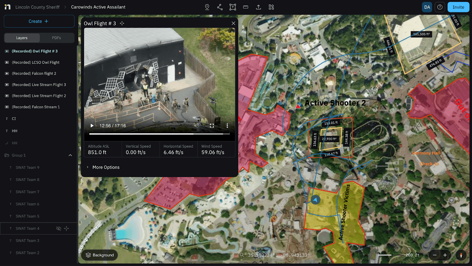
Carowinds Active Shooter Drill
At a large-scale multi-agency exercise at Carowinds Theme Park, over 300 personnel representing 40 agencies including Charlotte Fire, Charlotte-Mecklenburg Police, the FBI, the U.S. Army’s 91st Civil Affairs Battalion, and the American Red Cross came together for an intensive active shooter and disaster preparedness drill.
The Lincoln County Sheriff’s Office (LCSO) deployed Nova as their mission software to bridge aerial and ground operations. Prior to the exercise, their UAS division and SWAT team used Nova to pre-map the entire park, creating detailed situational maps with tactical points of interest. This gave every participating agency a unified visual reference before the scenario even began.
During the live exercise, two drones streamed simultaneously through Nova’s multi-stream link, providing real-time overwatch of the SWAT team’s movements. The live feeds were viewed not only by incident command, but also by military observers and surrounding counties, all watching the same synchronized stream in real time. This level of visibility allowed leadership teams to monitor operations, adjust tactics on the fly, and maintain visual contact with ground units throughout the drill.
By the end of the exercise, the entire command network across agencies and jurisdictions had operated with a single, shared view of the mission. The recorded streams were automatically stored in Nova for after-action review, helping teams analyze coordination, improve communication workflows, and strengthen future response plans.
“Nova has completely changed the way we operate. What used to take multiple platforms and a lot of manpower is now streamlined into one system that gives us instant intelligence. From pre-mapping a venue to live multi-stream overwatch, Nova has given us the real-time clarity and shared operational picture we need to keep our deputies, our partner agencies, and our community safer. It has become one of the most impactful tools in our entire special operations toolbox.”
-Andrew Alvarado, Lincoln County
Watch: More than 300 first responders train at Carowinds for emergency situations.
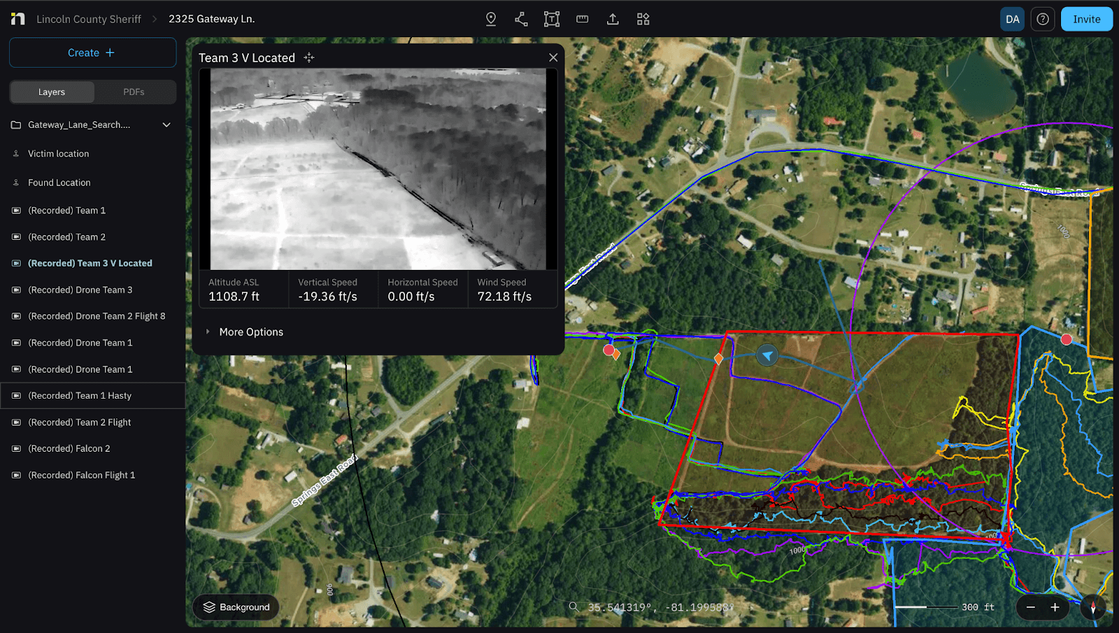
Search and Rescue: Real-Time Eyes on the Ground
In another mission, Nova proved instrumental in locating a missing 17-year-old girl outside Lincolnton, NC. Deputies launched their UAS and streamed live video directly to central command using Nova.
By integrating their SARTopo grids into the Nova interface, command could see both the drone’s livestream and the mapped search sectors simultaneously enhancing coordination between aerial teams and ground crews.
That real-time clarity helped responders focus their efforts, ultimately leading to the safe recovery of the missing person.
Results: Clarity, Speed, and Collaboration
Implementing Nova transformed how LCSO operates:
One Platform, Multiple Missions: A single system now supports SWAT operations, active threat training, SAR, and mutual aid coordination.
Real-Time Situational Awareness: Multi-stream capabilities and live mapping provide immediate command insight.
Post-Mission Review: Secure cloud storage and replay features allow for rapid training and documentation.
Scalable Adoption: Simple onboarding means new pilots and partners can be mission-ready quickly.
Nova’s ability to merge live streaming, mapping, and collaboration tools into a single environment continues to give LCSO the edge in preparedness and response.
The Future of Connected Operations
Lincoln County Emergency Management has been a vital partner in every major operation. Their coordination, resources, and support have strengthened our response capabilities and allowed our drone team and deputies to operate with greater clarity, safety, and efficiency.
As mutual aid partnerships grow and technology becomes central to emergency response, LCSO’s use of Nova sets the standard for regional collaboration and intelligent coordination.
Nova is proud to support the men and women of Lincoln County Sheriff’s Office as they lead with innovation, preparedness, and commitment to public safety.
Start for free today.
Craft the future. Respond to the present.