Back to blog
Apr 7, 2026
Case Study
Incident Overview
Wildfire mop-up is a critical phase of suppression, focused on identifying and extinguishing remaining hotspots to prevent reignition. While effective during daylight hours, mop-up operations become significantly more challenging at night due to limited visibility.
In July 2024, the Sacramento Metropolitan Fire District conducted nighttime mop-up operations on active wildfires. Crews relied on standard field methods such as headlamps, vehicle lighting, and occasional thermal imaging, but locating smaller, residual hotspots remained a persistent challenge.
This use case highlights the growing role of UAV programs and the increasing need for integrated mapping and thermal analysis tools to improve efficiency, accuracy, and confidence during nighttime operations.
Limited Visibility Slows Mop-Up Operations
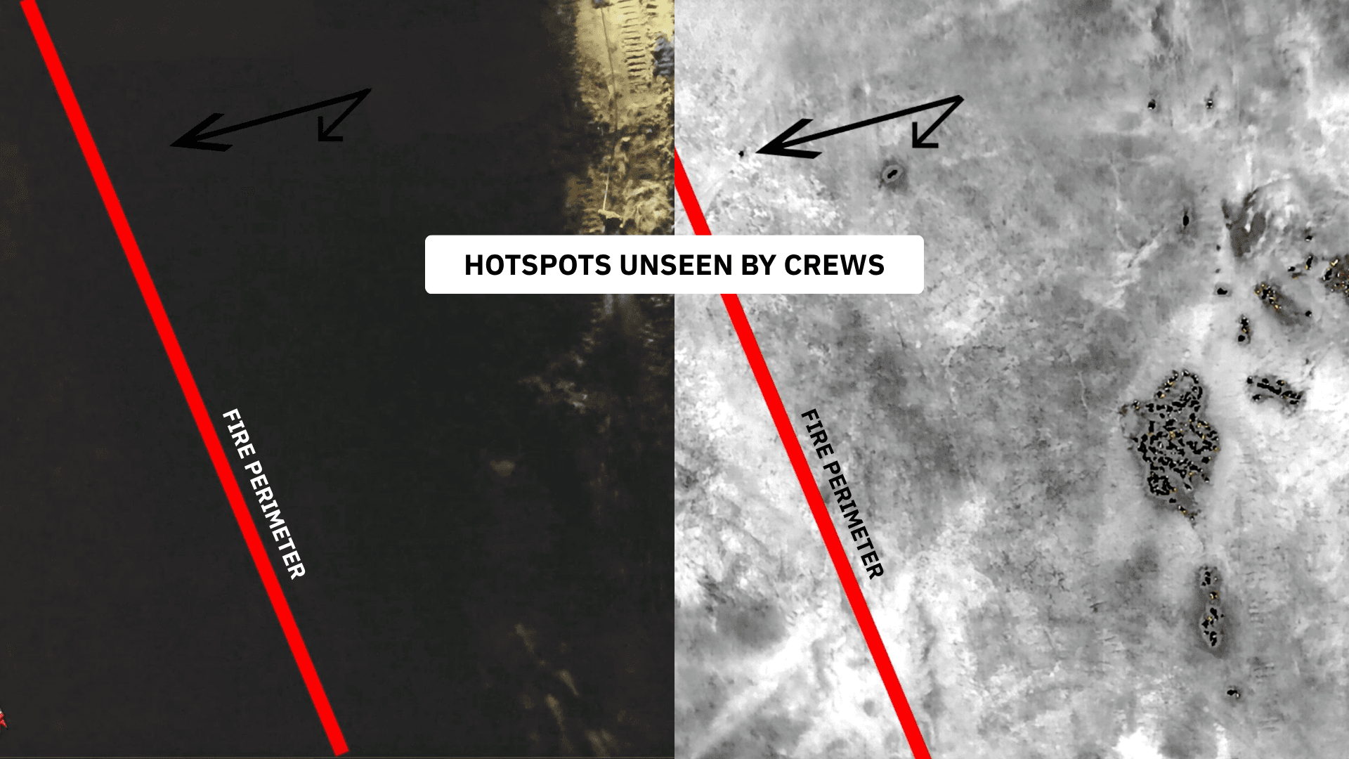
During nighttime operations, crews are able to locate and suppress larger hotspots with standard equipment. However, smaller and more dispersed heat sources are significantly harder to detect, increasing the risk of missed hotspots and prolonging mop-up timelines.
Historically, crews relied on a combination of ground-based visual identification, limited access to handheld thermal imaging, and UAV flights where operators manually identified hotspots through the controller feed. While these methods provided some level of visibility, they required continuous interpretation and coordination, making the process both time-intensive and dependent on individual operators in the field.
This workflow slowed the identification of residual heat, limited the ability to generate a complete and shareable view of the fire area, and reduced confidence in confirming that all hotspots had been addressed. As a result, crews were often working with an incomplete picture of the incident, extending mop-up timelines and increasing operational strain.
Advancing UAV Capabilities
As the UAV program matured, the Sacramento Metropolitan Fire District identified survey missions, photogrammetry, and thermal processing as the next step in advancing their operations.
Tools like Nova’s orthomosaic mapping and hotspot detection represent a shift from manual observation to automated, data-backed analysis. During this mission, UAV personnel spent approximately one hour mapping a single flank and guiding crews to hotspots via radio. While effective, the lack of integrated mapping and analysis limited how far that data could be leveraged across the broader operation.
This highlighted a key insight: Without integrated mapping and thermal intelligence, UAV programs cannot reach their full operational potential.
Nova for Mapping and Thermal Intelligence
Nova introduces a more structured approach to wildfire mop-up by combining:
Orthomosaic mapping for a complete, high-resolution view of the incident area
Thermal hotspot detection to identify residual heat sources
Georeferenced outputs that can be shared across teams
What was once considered a “nice-to-have” capability is now an operational expectation for mop-up with Sacramento Metro Fire.
This approach reduces reliance on manual interpretation and gives teams a more consistent way to identify and act on critical information in the field. With mapped thermal data and georeferenced outputs, crews can locate hotspots more efficiently, reduce time spent searching, and provide command staff with a clearer understanding of conditions across the incident.

Integration and Workflow Expansion
A key advancement for the department was integrating UAV outputs into existing systems. By connecting Nova with their ESRI-based GIS platform and Tablet Command, aerial data was extended beyond the UAV team into broader incident operations.
This allowed teams to deliver high-quality maps directly to command staff, improve situational awareness across crews, and strengthen the connection between aerial intelligence and ground operations. As a result, data collected in the air becomes immediately usable in the field rather than remaining isolated within UAV workflows.
The Impact of Faster, More Confident Mop-Ups
The primary objective for the UAV team is to improve efficiency while delivering reliable, high-confidence data to incident commanders and company officers.
With improved access to aerial intelligence, agencies are able to resolve incidents more quickly, increase confidence in hotspot identification, and reduce the amount of time crews spend in extended mop-up operations. This not only improves operational efficiency, but also supports responder safety and overall readiness for future incidents.
“UAVs are changing mop-up by providing real, objective data that works alongside and reinforces the efforts of crews on the ground, especially during low-visibility operations.”
– Matt Dargan, UAV Program Manager at Sacramento Metropolitan Fire District
Final Thoughts
As wildfire operations continue to grow in complexity, agencies are placing greater emphasis on improving both efficiency and confidence during critical phases like mop-up. The Sacramento Metropolitan Fire District’s experience highlights how limited visibility, manual workflows, and fragmented data can slow progress, and how integrating aerial intelligence into operations creates a more complete and reliable understanding of the incident.
By combining UAV capabilities with mapping and thermal analysis, teams are better equipped to identify residual hotspots, reduce time spent searching, and operate with greater consistency in the field. As these tools become more integrated into existing systems and workflows, they are not only improving operational efficiency, but also strengthening coordination, increasing confidence in decision-making, and helping agencies return resources to service more effectively.
This shift reflects a broader evolution in how UAV programs are being used, not just to observe incidents, but to provide actionable information that directly supports crews on the ground in real time.
Want to hear directly from Sacramento about their experience with Nova and the impact of their UAV program? Feel free to reach out and connect with their team.
Matt Dargan - FF/UAV Program Manager: dargan.matt@metrofire.ca.gov
Bryan Barthel - BC of Special Operations: barthel.bryan@metrofire.ca.gov
Mark Nunez - Public Information Officer: nunez.matt@metrofire.ca.gov
Start for free today.
Craft the future. Respond to the present.