Back to blog
Apr 1, 2026
Case Study

Incident Overview
Hazardous materials incidents often present a complex challenge for response teams. Determining the extent of contamination, identifying affected areas, and documenting the scene are all critical steps in protecting public safety and guiding mitigation efforts.
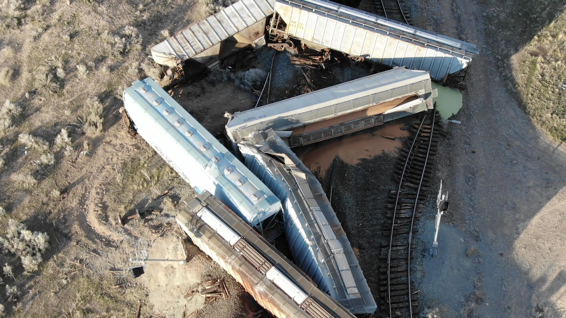
During a real-world response involving a rolled-over oil tank truck carrying approximately 100 barrels of Yellow Waxy Crude, the Utah State Fire Marshal’s Office utilized drone imagery and Nova’s mapping tools to better understand the spread of contamination and support incident documentation. The spill ultimately affected approximately 2,500 square feet of terrain, requiring detailed assessment and coordination for effective response.
The incident occurred in an area associated with Uinta Basin oilfields, where the distinctive yellow color of the crude oil created an opportunity to test and demonstrate Nova’s Colorfinder feature in a real operational environment.
This event became an important example of how aerial intelligence and image analysis can assist HazMat teams during complex response scenarios.
The Challenge: Identifying Contamination in Complex Terrain
When hazardous materials are released into the environment, it is often difficult for responders to determine how far the contamination has spread. In many cases, the affected areas may extend beyond what can easily be seen from the ground.
Traditional response workflows rely on:
Ground observations
Air monitoring data
Manual documentation of spill boundaries
While these methods remain essential, they can be time-consuming and limited in scope, especially in large or uneven terrain.
In this incident, responders were faced with determining:
Where the spilled crude oil had migrated
Which areas required containment or remediation
How to document the contamination footprint for investigation and reporting
To address these challenges, the Utah State Fire Marshal’s Office deployed drone-based aerial imaging to capture a comprehensive view of the scene.
Deploying Nova for Rapid Mapping and Scene Analysis
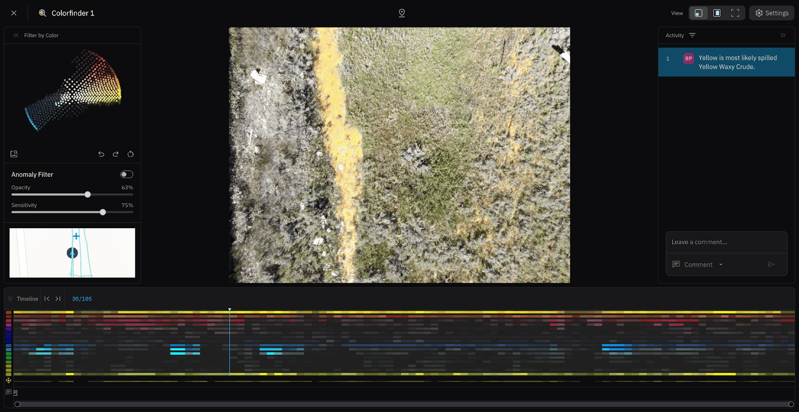
Using drone imagery collected over the spill site, responders uploaded the dataset into Nova to generate orthomosaic maps of the incident area.
Orthomosaic processing allowed the team to stitch together hundreds of aerial images into a single high-resolution, georeferenced map, providing responders with a detailed visual representation of the spill environment.
Once processed, investigators were able to analyze the scene from a broader perspective, identifying areas where oil had migrated across the landscape.
This aerial view provided several operational advantages:
A clear visual record of the spill footprint
Improved situational awareness for investigators
Documentation of the scene for post-incident reporting
The ability to overlay additional datasets such as air monitoring data
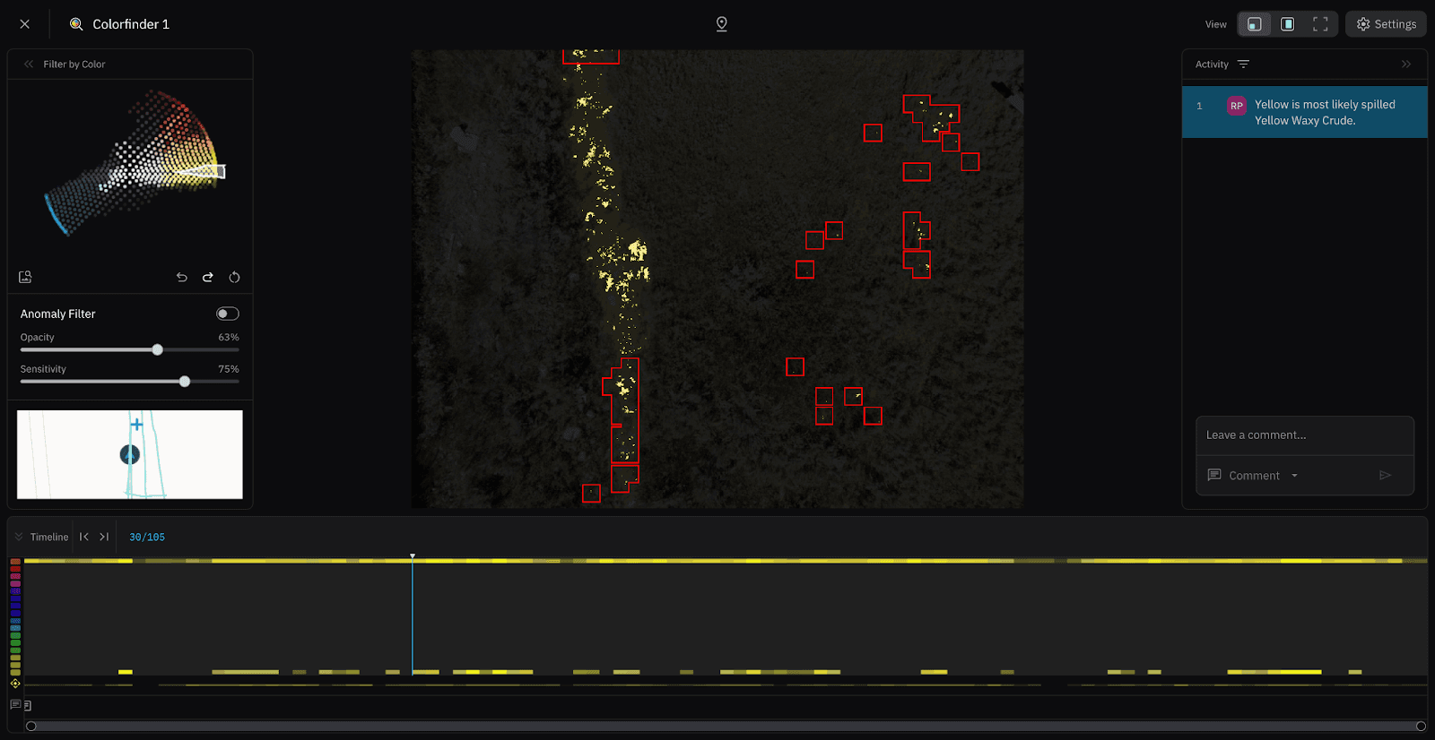
Colorfinder finds oil in the sagebrush on the right side of screen
Using the Colorfinder Tool to Detect Oil Contamination
One of the most valuable aspects of this incident was the ability to test Nova’s Colorfinder tool using the distinctive coloration of Yellow Waxy Crude.
Because this type of crude oil appears bright yellow, it created an ideal scenario for demonstrating how color analysis can help identify contamination that might not be immediately obvious in standard imagery. Colorfinder allowed teams to identify contamination in real time rather than relying solely on post-incident analysis.
By using Colorfinder within Nova, investigators were able to:
Scan the aerial imagery for the distinct yellow color signature of the crude oil
Highlight areas where contamination appeared in the dataset
Identify spill patterns and possible migration paths
This capability allowed teams to quickly locate areas where oil had spread across the environment, supporting both environmental assessment and cleanup planning. This real-time visibility enabled faster decision-making in the field and more targeted response efforts.
“I like how Colorfinder and hotspot detection allow for advanced analysis, yet Nova is still simple enough for public safety personnel to leverage—without a GIS degree.”
— Ryan Putman, Deputy State Fire Marshal
Integrating Air Monitoring and Incident Data
To further strengthen the analysis, investigators uploaded geo-referenced air monitoring data into the Nova project.
This allowed responders to correlate:
Aerial imagery
Detected oil contamination
Multi-gas air monitor readings
Combining these datasets provided a more comprehensive understanding of the incident, helping teams evaluate potential exposure areas and confirm where hazardous materials were present.
The result was a layered operational view of the incident, where aerial imagery and field data could be analyzed together within a single platform.
Improving Hazmat Documentation and Investigation
Beyond immediate response needs, the ability to generate detailed aerial maps also provided value for post-incident investigation and documentation.
Using Nova, investigators were able to preserve a detailed visual record of the spill scene that could be referenced later during:
Incident reporting
Environmental impact assessments
Investigative analysis
Training and case review
Having this level of documentation helps agencies maintain a clear historical record of the incident and supports transparency during investigation and remediation efforts. The aerial imagery and analysis were also used by cleanup teams during remediation, helping guide efforts and confirm affected areas throughout the process.
Lessons Learned from the Incident
The Utah State Fire Marshal’s experience during this incident highlighted several important takeaways for agencies responding to hazardous materials events.
Aerial perspective improves situational awareness
Drone imagery provided responders with a clear understanding of the spill area that would have been difficult to achieve through ground observations alone.
Color analysis can accelerate contamination detection
Tools like Colorfinder allow responders to quickly identify visually distinctive materials within large datasets, helping teams locate affected areas more efficiently.
Integrated data supports better decision making
Combining aerial imagery with geo-referenced monitoring data creates a more complete operational picture, allowing teams to validate findings and guide response strategies.
Drone mapping strengthens incident documentation
High-resolution orthomosaic maps provide an accurate and defensible visual record of incident conditions that can support investigation and reporting.
Future Opportunities for Hazmat Response Workflows
The incident also highlighted opportunities for continued improvements in drone-based Hazmat analysis.
One potential enhancement identified during the review process is the ability to draw lines and polygons directly within the Colorfinder tool. This would allow investigators to outline the boundaries of detected contamination areas more easily and communicate spill extent more clearly to response teams.
Expanding tools like this could further improve the ability of agencies to map, measure, and document hazardous material releases directly from aerial datasets.
Start for free today.
Craft the future. Respond to the present.