Back to blog
Jun 5, 2026
Case Study

The Virginia Department of Forestry does not approach drones as a technology initiative. For personnel using them in the field, the value is far more practical. In active fire environments, where decisions are made quickly and conditions can shift within hours, the real challenge is often not collecting information, but making that information usable for the people responsible for responding on the ground.
For Bill Perry, Area Forester with the Virginia Department of Forestry, that distinction matters. Perry has spent more than two decades with the agency and entered drone operations only within the last several years. Unlike the stereotype often associated with drone programs, he does not describe himself as a technology-focused person. His interest came from operations, specifically from finding ways to provide crews with information that helps them work more effectively in difficult conditions.
The Challenge of Seeing What’s Happening on the Ground
In wildfire operations, crews are frequently forced to make decisions with limited visibility. Fire behavior changes overnight. Hotspots remain hidden beneath vegetation or debris. Ground personnel may spend hours walking containment lines trying to identify areas that still hold heat.
“Anytime I think I need to walk a block, I stop and ask whether the drone can do it instead.”
– Bill Perry, Area Forester at Virginia Department of Forestry
During periods of elevated fire activity, multiple incidents may be unfolding simultaneously, placing additional pressure on personnel responsible for coordination and suppression efforts.
For agencies like the Virginia Department of Forestry, aerial infrared mapping has become one way to reduce that uncertainty.
Perry describes periods during peak burn season where crews may conduct multiple aerial ignition operations in a single week across different regions of the state. At the same time, wildfire personnel are balancing prescribed fire operations, initial attack responsibilities, mop-up coordination, and ongoing forestry management work. Drone operations are often layered onto existing responsibilities rather than functioning as standalone positions. In Perry’s case, drone work remains collateral duty alongside his broader operational role as Area Forester. That reality influences how aerial data is used. The goal is not producing imagery for its own sake. It is producing information that crews can act on quickly.
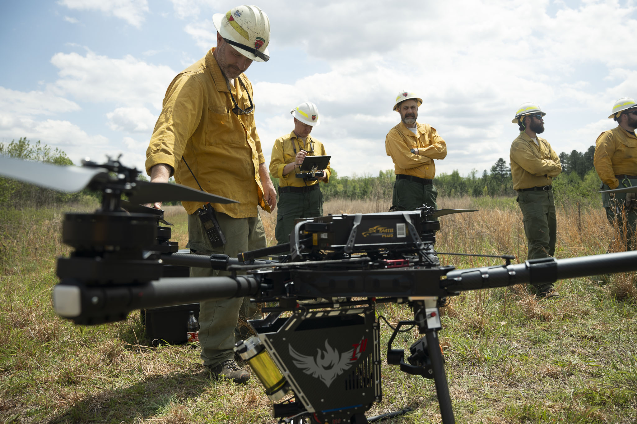
Photo courtesy of the Virginia Department of Forestry. Photo credits to the agency's Communications Specialist.
Why Aerial Mapping Became Part of the Workflow
One recurring challenge in wildfire response is ensuring that information gathered from aerial operations reaches the people who need it in a usable format. Perry explained that his workflow centers around exporting infrared hotspots and fire perimeters into shared mapping environments so personnel across the agency can access them in real time.
Rather than relying solely on static reports or verbal updates, these shared maps provide a common operational picture that supports decision-making across different roles and jurisdictions. That information becomes especially valuable during transitions between operational periods.
Turning Infrared Data Into Actionable Information
In a series of railroad fires caused by sparks from a passing train, aerial infrared mapping was conducted following overnight fire activity. Perry had initially worked the fire as a dozer operator during suppression efforts before returning the next morning to conduct infrared flights and create hotspot maps for incoming crews. The resulting data was then shared with the task force leaders responsible for mop-up operations.
The importance of those maps became clear when infrared imagery identified isolated heat sources outside the primary fire perimeter, including burning railroad ties that had been scratched in by local fire departments but were not part of the tracked fire area. Without hotspot mapping, those areas may not have been revisited, as they sat outside the assumed operational footprint.
Supporting Crews During Active Fire Response
For crews on the ground, that kind of information changes how work is prioritized. Rather than searching large areas without context, personnel can focus attention on locations most likely to create future problems. Perry noted that while crews may not necessarily navigate directly from hotspot to hotspot, the mapping provides guidance that helps determine where to concentrate time and resources.
The broader value is not simply identifying heat, but improving coordination across teams working the same incident. Wildfire response involves multiple layers of responsibility: field crews, dozer operators, incident leadership, regional foresters, and cooperating agencies. Each group depends on timely information, but each uses that information differently. Perry routinely shares generated maps with leadership personnel, including regional supervisors, as the data provides operational awareness beyond the immediate fireline.

Photo credit: Virginia Department of Forestry.
Expanding Drone Use Beyond Wildfire Response
While wildfire response is the most visible application of drone use within the Virginia Department of Forestry, it is not the most common. The agency has also incorporated drone operations into broader forestry management work.
Perry described using aerial mapping to support acreage determination for herbicide treatments, reforestation planning, and cost-share programs on private lands. Accurate acreage measurements are essential, as state forestry programs may cover a substantial portion of treatment and planting costs for landowners.
Drone mapping has also been used following severe weather events to assess timber damage in areas where ground access would require significant time and physical effort. Following an ice storm, aerial imagery helped personnel evaluate whether damaged stands were salvageable without requiring crews to navigate dense debris and overgrown vegetation.
In many of these situations, the decision is simple: if the information can be gathered from the air, it reduces the need to put personnel on the ground unnecessarily.

Photo credit: Virginia Department of Forestry.
A Tool Built Around Operational Need
Perry summarized his perspective simply. The purpose is not to use drones for the sake of using drones. The purpose is to make work easier for the people in the field and provide information that helps them make better decisions.
That philosophy reflects a broader shift occurring within emergency response and forestry operations. The most valuable operational improvements are often the least dramatic. They are the small improvements that help crews understand conditions more clearly, prioritize work more effectively, and coordinate across teams with greater confidence.
For the Virginia Department of Forestry, aerial mapping and infrared workflows are becoming part of that evolution, not as a replacement for operational experience, but as another tool supporting the people responsible for protecting landscapes and communities under increasingly demanding conditions.
We are proud to continue supporting the Virginia Division of Forestry as a node in their aerial intelligence workflow. Thank you to Bill Perry for taking the time to sit down and talk about the incredibly successful program they have built.
Start for free today.
Craft the future. Respond to the present.