Back to blog
Jul 29, 2026
Journal

Most of the agencies we talk to don't have a GIS department. There's no cartographer on staff, nobody holds a certificate in remote sensing, and the person "in charge of mapping" also answers the radio, orders truck parts, or runs the drone program out of the back of their own truck between other duties.
If that's you, you're not the exception. You're most of our customers.
What GIS actually is, in plain terms
A regular map shows you where things are. GIS is a mapping system with data attached to every point on it, so instead of just gleaning knowledge by looking at it like an old fold up in a glove box , you can ask it questions and get answers back.
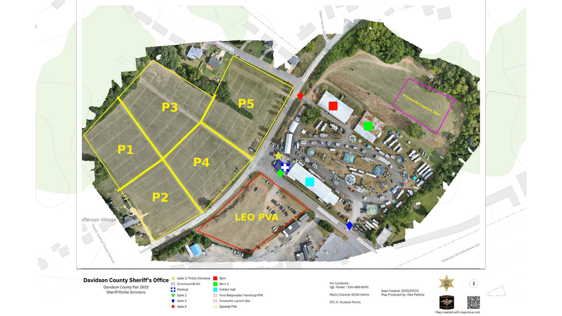
You're probably already using GIS without calling it that. Your Computer-Aided Dispatch (CAD) system pinning where a 911 call is coming from, your CalTopo or SARTopo terrain map, your county's parcel map showing who owns what property: All three are running on GIS underneath the surface. They're not just pictures of an area. They're layers of information tied to real-world locations.
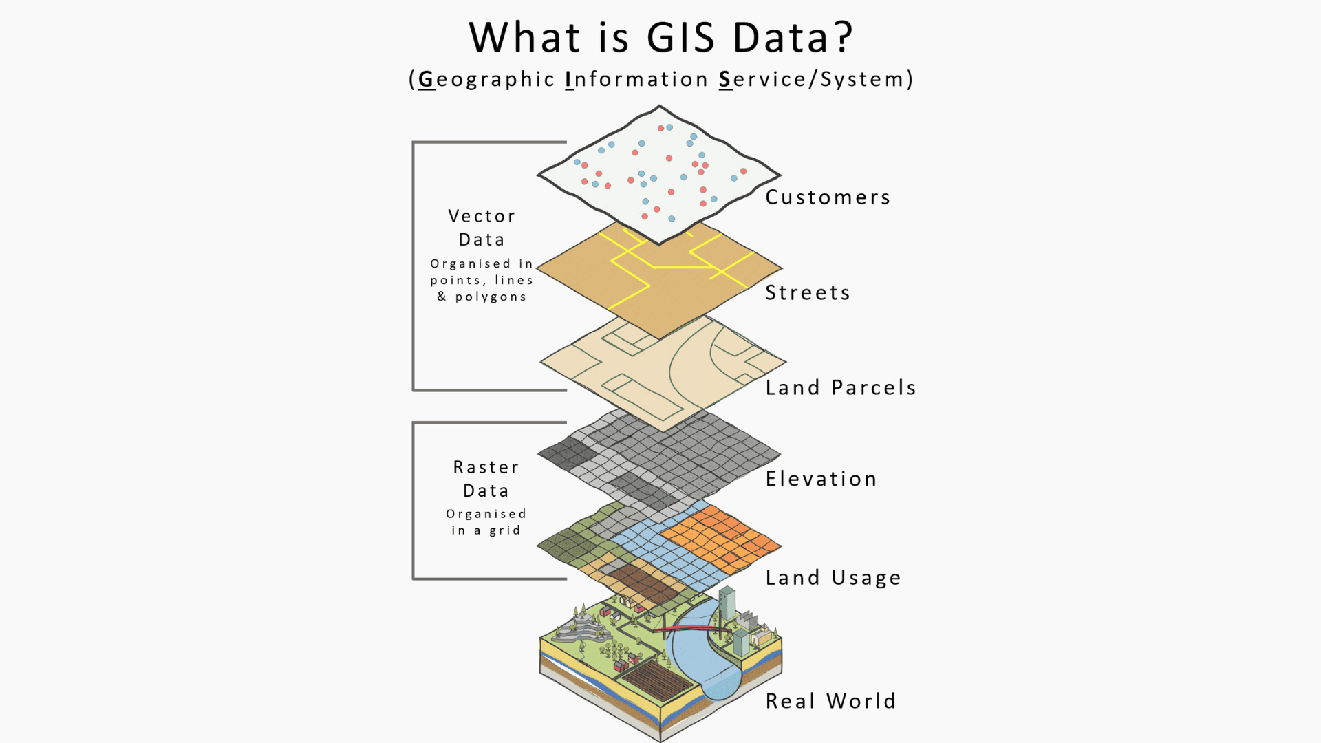
Think of a paper map with transparent sheets stacked on top; one for hydrants, one for flood zones, one for last year's call volume. GIS is that stack working together as one coherent source of information, except it's digital, always up-to-date, and it can do the geography math for you, such as highlighting every house within a half mile of a fire instead of you eyeballing it off a printed page.
A quick history of why it still feels hard
The concept of GIS goes back to the 1960s, but the moment that built the GIS industry as we know it was 1982 when Jack and Laura Dangermond released Arc/INFO through their company Esri: Environmental Systems Research Institute Inc.Esri is widely credited as the first major commercial GIS software. That's over 40 years of a single category of software getting deeper, more capable, and considerably harder to learn along the way.
Real proficiency isn't a weekend skill. Depending on the learning path taken, becoming genuinely competent in a traditional GIS software runs anywhere from an 8-month certificate program to a full four year degree. That's not a criticism of the software, it’s just the reality of how much there is to learn when it comes to GIS. It's such an in depth and powerful tool because it was built for people whose entire job is spatial analysis. It was never built for someone whose job is running a fire department, a forestry crew, or a patrol shift, with mapping stacked on top as one more responsibility.

The assumption that holds departments back
A lot of agencies rule themselves out of drone mapping before they even try it, because the model in their head is the one above: a dedicated analyst running specialized GIS software, processing the imagery for days, and eventually handing back a static map that's usually at least a little out of date by the time it lands on someone's desk.
That model exists, and some large agencies run it well. It's also not how most fire departments, forestry crews, small-town PDs, or emergency management offices actually operate.There are far more efficient ways to get the same information faster and in higher quality nowadays using the existing tools your drone program has on hand. We built Nova to get you to the same end product: an accurate, usable map chock full of the annotations and information your department needs, all through a user-friendly process that doesn't require the specialist first.
What "no GIS team" actually looks like
In practice, it's a volunteer fire chief who also handles dispatch scheduling. It's a two-person forestry crew covering a county's worth of land. It's the one officer in a police department who happens to hold the Part 107 license and flies the drone on top of a full patrol schedule. None of these professionals have four years to become a GIS analyst, and none of them should have to.
Departments like those listed above are often operating off of large printed or hand drawn pages that haven’t been updated in years, sometimes even decades, due to the cost in both time and money. It doesn’t have to be a monumental task to update these systems. As long as you’ve got a drone capable of orthomosaic mapping, Nova can help you with the rest.
Where the bottleneck actually comes from, and where your drone fits
The hold-up in this process was never the flying portion. It was everything after the flight. Getting raw drone imagery into something usable has historically meant specialized software, a steep learning curve, and often a multi-day wait for someone else to process it. That's the piece we built Nova to remove.
Our workspaces are structured like an organizational chart you'd already recognize: regions, projects, and teams, not like a GIS database schema. Orthomosaics generate in a few steps and minutes, not a few days. Our AI-driven hotspot detection does the analysis automatically instead of asking someone to interpret thermal data by hand. Our colorfinder does the emergency infrastructure locating for you without having to pour over faded maps searching for yellow, red, or blue hydrants.
Here's the part worth understanding: when Nova builds a map or drops a hotspot pin with real coordinates, that's GIS data. That's why exporting a georeferenced file from Nova into a tool like Avenza, SAR Topo, or TAK actually matters; both systems speak the same location language, so the information your drones find lands exactly where it should on the command map instead of someone guessing. Your drone is, in effect, a GIS data collector that flies.
You don't need to hire anyone to start
If the only thing standing between your agency and a mapping program has been the assumption that you need a GIS analyst on staff first, that assumption is the thing to drop, not the program. The agencies getting the most value out of Nova right now are, overwhelmingly, the ones without a GIS department. Our software was built for the person doing this job alongside five other jobs, not for a specialist with nothing else on their plate.
GIS is a map that carries information and answers location questions. It's the common language that lets your CAD, your mapping tools, and your drone all put the same incident in the same spot. You don't need a department to speak that language. You need software that already does.
Start for free and see what your team can build without hiring anyone new to build it.
Start for free today.
Craft the future. Respond to the present.